Hurricanes
Hurricane Otis
 Mexico
 Category 5 Storm
 24 October, 2023
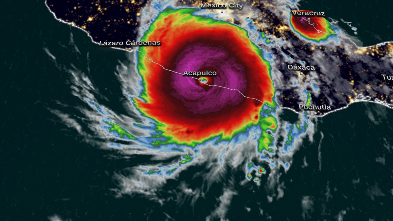
 Hurricane Otis made landfall in Acapulco, on the Pacific coast of Mexico just after midnight on Wednesday 24th October.
The Category 5 hurricane brought winds of up to 165 mph and is the strongest storm to make landfall on Mexico’s west coast. This hurricane caught many by surprise because it went from a Category 1 hurricane to a Category 5 hurricane in just 12 hours, which is one of the fastest rates ever recorded.
None of the main modelling platforms predicted this storm, increasing the magnitude of its impact, given the residents and local authorities were prepared to expect a Tropical Storm.
The National Hurricane Center said on Tuesday evening that “a nightmare scenario is unfolding for southern Mexico this evening with rapidly intensifying Otis approaching the coastline”.
Hurricane Otis has broken numerous records, not only did its severity increase by over 110mph in less than a day (surpassing the record set by Hurricane Patricia in 2015), but it’s also the strongest storm to directly hit the area. It is also the first Eastern Pacific Hurricane to make landfall at the intensity of a Category 5.
It is thought that the climate crisis and record-breaking ocean temperatures are creating stronger and more destructive storms in recent years. In addition to this, we are currently in an El Niño cyclical weather pattern (see below for further information).
The Hurricane continued its path from Acapulco inland across the mountainous state of Guerrero, the topography caused a swift de-escalation of intensity with the storm dissipating close to the city of Tixtlancingo around 5pm (CDT) on Wednesday the 25th of October.
The storm is bringing heavy rainfall to the region, which will cause significant flooding and mudslides in higher terrain. Parts of Mexico’s Pacific coastline have already been affected by flooding following Tropical Storm Max which hit earlier this month.
Map of the affected area
Extent of Damage
The Mexican Federal Electricity Commission stated that 504,340 customers’ homes and businesses in the region had been cut off from power, with reports of severe wind damage to properties on the coastline and along the path inland of the storm.
Landslides have also been triggered causing extensive damage to highways and roads in the region, including heavily affecting one of the main access routes into Acapulco.
Power Outages and Transport routes will have been severely affected across the regions, including train lines, airports and roads.
There is expected to be widespread damage to commercial and domestic properties. Commercial losses will likely be predominantly hotels, with some infrastructure and industry losses such as warehousing, logistics and manufacturing.
Acapulco was among the areas worst hit with 80% of the resort’s hotels damaged.
We will be monitoring the rainfall, particularly in the states of Guerrero and Oaxaca, because many more industries could be affected.
8,000 troops from Mexico’s Army and Navy have been deployed to the region to aid the recovery process and manage the situation.
BUSINESS INTERRUPTION COVERAGE ISSUES
- Government assistance considerations
- Prevention of access – inability to access businesses due to the closure of roads
- Property damage to local businesses
- Public utilities – damage to providers of electricity, gas, sewage, and telecommunications
- Closure of premises by public authority – closure or evacuation of Insured premises
- Losses resulting from supply chain issues.
Early involvement of the appropriate experts can help with the need for any mitigation efforts.
MDD has considerable expertise in dealing with these types of claims and the complexities that may occur. Experts like those of us at MDD will stress the need for proper audit protocols, controlling and sorting of costs and accounting for any potential saved expenses.
We have 30+ Spanish speakers who are ready and available to assist – the majority of which are located in the Americas.
El Niño
The Pacific waters of South Mexico are warmer than usual because of the El Niño weather phenomenon.
During normal conditions in the Pacific Ocean, trade winds blow westward along the equator, carrying warm surface ocean water from South America toward Asia. To replace this warm water, cold water rises from below during a process called “upwelling.”
During El Niño, the trade winds weaken (and sometimes even reverse). As a result, warm surface water is pushed eastward toward the west coast of the Americas, with significant impacts on the climate.
El Niño causes severe climate disturbances from Australia to South America. Australia and Indonesia often experience droughts in an El Niño year, the Caribbean coast of Central America will often experience excessive rainfall, while the Pacific coast remains dry. Convection from warmer surface waters increases precipitation along the coasts of Ecuador, northern Peru, and southern Chile. Precipitation tends to decrease in Colombia, Venezuela and Guyana and there are often droughts in northeast Brazil. Increased rainfall in the southern tip of South America causes a rise in the region’s water levels.
During an El Niño cycle, we are often retained to quantify damages resulting from:
- Floods
- Landslides
- Wildfires
To learn about the varying effects of a La Niña cycle (opposite of El Niño) on Business Interruption claims click here.
Related Updates
Contact a member of our local team below to discuss your needs.
New Assignment


