
Measuring Business Interruption Claims: A Case Study From Christchurch and Kaikoura Earthquakes
 10 April, 2025
-
 APAC
APAC
Earthquakes are a historically prominent event in New Zealand, occurring most commonly in the Southern and Eastern areas of the North Island and most of the South Island.
This is because New Zealand falls over the Australian and Pacific tectonic plate boundaries which typically form a subduction zone. The main north and south subduction zones are linked by a series of large fault lines as shown below.
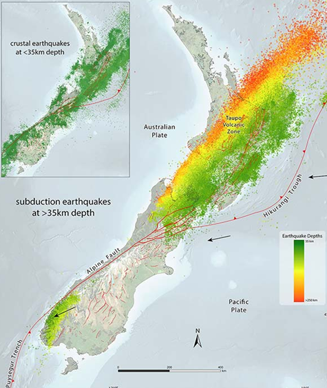
Sub–parallel fault lines subsist through Marlborough at the Northern tip of the South Island (Marlborough Fault System), which is in close proximity to the capital of Wellington. Connecting to this fault system and travelling down the West Coast of the South Island is the Alpine Fault.
Along the Alpine Fault, plates are not only moving past each other but are also moving towards each other. This compressional movement has contributed over time to the rise of a parallel mountain range known as the Southern Alps.
Christchurch Earthquakes
Christchurch City is New Zealand’s third most populated city, the most populated city in the South Island, and is located in the Canterbury region in the central of the South Island. Between 2010 and 2011, four significant earthquake events occurred:
- 4 September 2010, 7.1 magnitude earthquake, weakened the buildings and infrastructure;
- 22 February 2011, 6.3 magnitude aftershock with an epicentre 10 kilometres west of the city and 5 kilometres deep. Extensive damage to buildings, infrastructures, and unfortunately significant loss of life. New Zealand’s second deadliest earthquake on record after the Napier Earthquake in 1933;
- 13 June 2011, 6.0 magnitude aftershock, followed by intense aftershocks ranging from magnitudes 5 to 6; and
- 23 December 2011, 5.9 magnitude aftershock, followed by intense aftershocks ranging from magnitudes 5 to 6.
Across the four events, the Canterbury region suffered extensive infrastructural damages, including collapsed buildings and ruptured utility lines, with losses in excess of NZD$45 billion inflation adjusted.
Kaikoura Earthquake
On 14 November 2016, Culverden, an hour’s drive north of Christchurch, was struck by a 7.8 magnitude earthquake with a depth of 15 kilometres – the second highest magnitude in New Zealand’s history.
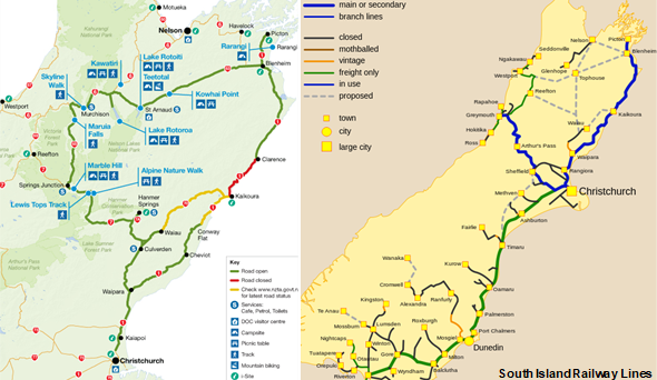
This event led to the immediate closure of key transport routes, including State Highway (“SH”) 1 and the Inland Kaikoura Road, effectively isolating Kaikoura and nearby communities.
The main trunkline railway was severely damaged, and it took approximately a year to restore the rail service to Christchurch, with operations recommencing in September 2017.
Damage was also sustained to buildings and infrastructure throughout the Wellington Region and disrupted operations at the Port of Wellington.
Travellers were forced to take alternate inland routes via SH 63, SH 6, and SH 7 as seen in the image below. Using the longer alternative routes resulted in increased freight and transportation costs, resulting in losses for manufacturing and transport dependent industries.
Insurance Coverage
Earthquakes are known for causing a wide range of damage such as but not limited to structural damage, land movement and erosion, liquefaction, and depending on the circumstances can potentially increase the risk of or contribute to subsidence, volcanic eruptions, and tsunamis.
In part, this may be why Business Interruption resulting from an earthquake event generally falls under Natural Disaster coverage limits, which can be more limited in comparison to other perils.
Despite the propensity of earthquakes to cause a large variety of potential damage, often many businesses sustain no physical damage. Further, due to a range of factors such as changing subsurface topographies, there can be situations where damage is extensive to one structure, but others immediately adjacent remain unscathed – making the risk of damage less predictable.
Businesses unscathed by damage instead may still be impacted by offline utilities, prevention of access, authoritative closures, transport route and port closures, third-party damage, or combinations of these.
In the absence of physical damage to insured property, ordinary Business Interruption insurance will not automatically respond for claimants seeking reparation for lost Gross Profit, Increased Cost of Working, or Extra Expenses.
Many businesses however have Dependency or Contingency Coverage Extensions to cover their dependencies on third parties, utilities, transport routes and ports, and the like. For businesses that did not sustain physical damage, this presented an opportunity to claim for Business Interruption losses directly caused by these contingent perils.
Business Interruption Coverage Issues
The most recent Christchurch and Kaikoura events led to a number of situations affecting businesses, some of which are common to widespread disasters and others more unique to earthquakes.
Notably the development of red zones and exclusion zones by authorities, depopulation, proximity restrictions for closure of transport routes and prevention of access, and proximate cause challenges in the wake of multiple events.
These issues are discussed in further detail below.
Red Zones
Red zones are areas of land deemed unsuitable to rebuild. This is usually as a result of a Public Authorities intervention to relocate suburbs, towns, or cities largely due to ensuing soil liquefaction.
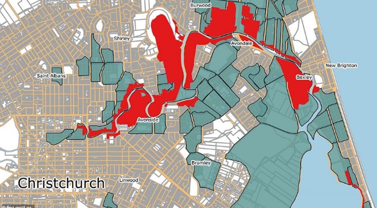
Where businesses were within these red zones, Business Interruption could trigger either from damage sustained to insured property or through contingent causes such as prevention of access due to closure or evacuation by an Authority.
In the context of businesses that do not sustain damage but are in close proximity to red zones, Business Interruption could trigger through contingent causes such as from damage to a third party, or closure of transport routes forfeited within Red Zones.
The key challenge in this situation is that whilst such a business may be materially interrupted by such contingent causes for the foreseeable future, they are restricted in the length of their maximum indemnity periods, which is typically 12 months.
This was the case in Christchurch in the wake of the 2010 to 2011 earthquakes. Following the expiration of Business Interruption coverage, businesses were still impacted materially due simply to the fact that the mass relocation of people out of red zones nearby caused localised depopulation, left areas perceived as undesirable or unsafe to visit, drastically reduced customer foot traffic and, subsequently, profits.
Exclusion Zones
Exclusion zones enforced by Public Authorities are similar to red zones as areas temporarily excluded to the public. Whilst these zones can be rebuilt in contrast to red zones, the damage within exclusion zones is typically in built up areas. The risks of further structural deterioration and collapse of high rising structures from future ongoing aftershocks leaves the proximate area surrounding these structures a hazardous space to occupy until damage is assessed, structures reinforced or made safe, or in the worst cases, dismantled.
Given that most high rise buildings are concentrated in central business districts of cities, exclusion zones typically caused more widespread interruption to businesses than red zones which often reside over residential areas.
Exclusion zones were used in particular following the second earthquake in Christchurch where a number of large buildings sustained irreparable damage and were a risk to the public due to risk of falling materials, and partial or full collapse.
As a result, businesses located within exclusion zones were unable to operate and other nearby surrounding areas left areas perceived as undesirable or unsafe to visit, drastically reduced customer foot traffic and, subsequently, the performance of their businesses.
Again, where periods of contingent Business Interruption cover expired following a time period, businesses who continue to sustain an interruption to their business would likely be unable to claim the Business Interruption losses on an ongoing basis.
Proximity Restrictions
In some cases, where a contingent Business Interruption arises from prevention of access due to closure by an Authority (earthquake red or exclusion zones), there can be proximity restrictions determined by the proximate radius of a businesses’ insured property to a red or exclusion zone. Sometimes this is limited to just the Insured’s physical business location.
Despite the extensive impact following the second earthquake in Christchurch, for businesses who were subject to a proximity clause and who fell outside the threshold radius, this complicated Claim acceptance under this type of contingent cause.
Prevention of access due to damage or road closure also encounters similar challenges. New Zealand is heavily dependent on state highway infrastructure with limited alternatives such as passenger rail infrastructure (outside of Auckland City). Western, eastern, and northern areas of the South Island for example rely on a couple of key highways, making them susceptible to unusually long detour contingencies or, in some cases, there is no practical detour. Business Impact can therefore be amplified due to an intense dependency on these highways remaining open.
Following the Kaikoura earthquake, SH 1 and the main railway trunk line sustained severe damage, requiring as much as 12 months to reinstate and restore functionality for dependent businesses and the public. These are long passages of road and rail that are well in excess of radius restrictions typically seen between 1 KM to 50 KM. In the scenario where businesses in the Kaikoura area were subject to a proximity clause and fell outside any applicable threshold radius, this may have proved fatal to Claim acceptance under this type of contingent cause.
Depopulation
Depopulation is a common phenomenon following earthquakes. While depopulation contributed to less business activity, customer foot traffic, and local investment in the Christchurch economy, fixed costs such as insurance, rates, and water utilities among others increased materially for businesses that did continue trading.
Similarly to red and exclusion zones, when considering the ongoing performance of the business long term following the period of cover lapsing, businesses may continue to perform worse simply because of reduced population. This added a further complication to the measurement of Business Interruption losses.
In the case of Christchurch, approximately half a decade following the 2010 to 2011 earthquakes, record low property values in the region and the absence of further ongoing significant earthquake events among other variables contributed to a reversal of depopulation. In this scenario, businesses may have conversely seen growth in trading performance which would need to be considered with respect to any new or ongoing Business Interruption claims, whether earthquake related or not.
Proximate Causation
During the Christchurch earthquakes, many businesses were affected by multiple events and often simultaneously including power outages, prevention of access, exclusion zones, port and road closures, and damage to third parties, of which, all could be contributing to a sustained loss of profits.
Most claimants had these extensions to cover losses stemming directly from such dependencies, however, there may have been causes that fell outside the scope of cover and were not insured losses which must be separated. Separating these potential uninsured causes of loss became a significant quantification issue.
Identifying the dominant proximate cause of losses is challenging for Insurers and policy holders alike, and often requires a tailored approach for each case because of, but not limited to the following considerations:
- Different combinations of insured and uninsured loss changing across industries and geographies;
- Varying degrees of impact from earthquakes in both length and severity between regions, suburbs, and even adjacent blocks;
- Different coverage limitations, exclusions, and deductibles across the market;
- Quality of financial information available to substantiate different causes of loss;
- Changing regional economic environment seen over extended periods; and
These contribute to the absence of a one – size – fits – all approach.
Conclusion
Resources to manage the significant claims volumes are tested during earthquake disasters. The intensity of the earthquake and the proximity and depth of the epicentre to commercial civilisation is often a factor that drives higher claims volumes.
The added difficulty of dealing with a large volume of dependency claims arising from earthquakes means that Insurers had to rely very heavily on their panel of accountants to unravel the often tangled knot of multiple causation and then make sure that the correct policy application had been considered. This often included managing the expectations of the brokers and their clients.
As many of these claims were relatively low in value, efficient ways had to be found to deal with them to ensure that client expectations in both time and value delivery were met.
MDD has considerable expertise in dealing with these types of claims and the complexities that may occur in a time-efficient and cost-effective manner using its combination of local representation and regional and international depth of resources.
By Josh Herbert.
The statements or comments contained within this article are based on the author’s own knowledge and experience and do not necessarily represent those of the firm, other partners, our clients, or other business partners.
https://riseuprichmond.nz/red-zone-futures-land-maps-and-information/
https://www.britannica.com/event/Christchurch-earthquakes-of-2010-2011
https://www.kiwirail.co.nz/media/first-freight-train-rolls-through-kaikoura/
https://www.transport.govt.nz/assets/Uploads/Report/Kaikoura-Earthquake-MERIT-Report.pdf
https://interactives.stuff.co.nz/2019/09/christchurch-red-zone-to-green/
Kenneth’s guide to the alternative route (Picton to Christchurch)
Articles
Relevant Articles
Our experts are extremely knowledgeable about thier subject areas and often write educational material and commentary on topical issues they come across.

Measuring Business Interruption Claims: A Case Study From Christchurch and Kaikoura Earthquakes
Earthquakes are a historically prominent event in New Zealand, occurring most commonly in the Southern and Eastern areas of the North Island and most of the South Island. This is because New Zealand falls over the Australian and Pacific tectonic...

Understanding Business Interruption Following a Cyber Attack
Why Idle Labour Costs Are Typically Not an Indemnifiable Loss We have all experienced periods when suddenly our emails or internet go down. In instances such as these, short as they may be, it is only natural to feel lost...

MDD LA Wildfires Report
California Wildfires of January 2025: A Devastating Start to the Year The year 2025 began with a series of devastating wildfires that swept through Southern California, leaving a trail of destruction and significant insured losses in their wake. Fuelled by...

CAT Spotlight – Iceland
In this CAT spotlight, we focus on Iceland, situated on the Mid-Atlantic Ridge, a country prone to volcanic eruptions, earthquakes, and glacial floods. The most well-known CAT event in recent times was the March 2010 Eyjafjallajökull eruption. Most will remember...

Recapping the 2024 Hurricane Season
Whilst to most, 01 December marks the countdown towards the festive season, to others on the other side of the Atlantic, it also marks the end of the Hurricane Season (officially on 30 November). Initial Forecast vs. Actual Season Forecast Expectations:...

CAT Spotlight – Italy
In this CAT spotlight article, we look at Italy, where floods and earthquakes have caused the most damage over the last two centuries. As an example of the frequency of seismic events, Italy suffered over 16,000 in 2023, according to...

Measuring Business Interruption Dependency Claims: A Case Study from Cyclone Gabrielle
Cyclone Gabrielle made history as the costliest tropical cyclone in the southern hemisphere. Conceived as a tropical low North of Fiji in early February 2023, Cyclone Gabrielle intensified to as high as Category 3 storm. After downgrading to ex-tropical cyclone...
The Bottom Line of Catastrophe: How Catastrophic (CAT) Events are Impacting the Insurance Industry Worldwide
In this new series of spotlight articles, we look at how CATs are affecting different countries all over the world. These are snapshots of various countries CAT history and are designed to give the reader a basic understanding of the...

Floods in the South of Germany in June 2024: Highly Complex Business Interruption Losses
At the beginning of June 2024, unusually high precipitation occurred in large parts of southern Germany. This resulted in flooding and in property damage to residential and commercial properties over a large area. Initial estimates provided by the German insurance...

Predictions for the 2024 Hurricane Season: Implications for the Insurance Industry
“May 2024 (Tortola): it’s currently 30 degrees (Celsius) down there…” I’ve been very fortunate to experience first-hand the beauty of the Caribbean over the past few years, but you could imagine my surprise, when the diving instructor mentioned the above...

High Grade Ore And A Question Of Indemnity
When a mine suffers business interruption, the issue of high grading can come into play. The question is whether insurers should actually benefit? Mining business interruption insurance and the principle of indemnity is no simple matter. Take the case of...

El Niño – Weather Phenomenon & Global Disruptor
What is “El Niño”? In normal conditions in the Pacific Ocean, the trade winds blow westerly along the equator, bringing warm water from around South America towards Asia. In a process known as “upwelling”, cold water from the depths of...

Renewable Energy Losses – Winds of Change
It is May 20, 1899. New York City taxicab driver Jacob German is the recipient of the United States’ first-ever speeding ticket. He whizzed by at 12 miles per hour on Lexington Avenue and was then pursued and remanded by...

Business Interruption Considerations for Hotel Losses
Irrespective of the industry in which an Insured operates, the basic intent of business interruption (“BI”) coverage is to place the Insured back into the same position they would have been in had the insured peril not occurred. Those of...

CAT Insights – The Increasing Risk and Frequency of Wildfires
Depending on where you are located, you are likely to experience some sort of “weather disaster season,” such as hurricane season, cyclone season, tornado season, earthquake season, or wildfire season. I live in California where we have earthquake season, which...

Natural Catastrophe Insurance Coverage in Asia: An Overview
Natural Catastrophes in Asia In 2021, Asia was the most severely impacted region, experiencing 40.00% of all disaster events, 49.00% of total deaths, 66.00% of the total number of people affected and 18.90% of all natural catastrophe economic losses worldwide...

Property Damage and Derechos
On 29th June 2023, a rare type of storm called a "derecho" swept across the Midwest region of the United States, mostly impacting the states of Missouri, Illinois and Iowa. The derecho began as a rotating supercell thunderstorm that spawned...

Variable Mining Costs – How Should They Be Treated?
Variable expenses: one would consider this to be one of the easier aspects in the analysis of a mining claim; however, that is far from the truth. When it comes to mining losses, the determination of which costs are considered...

The Effect of Volatility on Power Generation Business Interruption Losses
It is clear to the casual observer that many aspects of the economy are facing volatility. Fuel, energy, labor, shipping - all have experienced unprecedented shortages and price increases because of a myriad of conditions. The Russia-Ukraine war, Covid-19, inflation,...

Waste to Energy
What is Waste to Energy? Waste to energy refers to the process of converting municipal solid waste (MSW), otherwise known as trash, into usable heat, electricity, or fuel. The three main MSW categories include: Biomass or biogenic (plant or animal...

Ghosts, Ghouls and Cyber Claims
We usually think of Hallowe’en when October rolls around; however, did you know that October is also cyber security awareness month? NetDiligence recently released the 12th iteration of their Cyber Claims Study. They analyzed approximately 7,500 cyber claims from period...

An Introduction to Natural Gas: Separation, LNG and GTL Plants
Our first technical briefing introduced the Oil & Gas value chain, divided into: i) upstream; ii) midstream; and iii) downstream. Here is a recap, before we explore natural gas in more detail. Upstream: this involves the exploration and extraction of...

The Broader Impact of CAT Events
While every catastrophe (“CAT event”) leaves a wake of destruction in its path, there are times when the financial impact is more widespread than the physical damage would indicate. Consider the following examples: Pandemic – 2020 The impact of COVID-19...

What to Do When Disaster Strikes & You Can’t Access Financial Documents
Swiss Re’s website sigma-explorer.com noted insured losses for 170 natural catastrophes and 105 man-made disasters in 2021 alone.[i] While almost all of these events resulted in property damage and loss of earnings for the affected businesses, some of those entities...

Mining BI Insurance: Remediation and Rehabilitation
All mines, no matter how vast or intricate, are ultimately temporary and will one day be depleted. When all valuable materials are extracted, or at least those that are cost-effective, mining operations will cease, and the mine will be decommissioned....

Calculating the Effects of a Natural Disaster
The Allianz Risk Barometer 2022 reported that natural catastrophes are now the third-highest global business risk, while climate change has moved into the sixth position. These rankings represent 25% and 17% increases from last year.[i] Furthermore, the increasing complexity of...

Renewable Energy Certificates
Since 1978, American regulators and policymakers have looked to incentivize the investment and development of generating renewable energy. Individual states began enacting Renewable Portfolio Standards (RPS) to support this mission by requiring a specific percentage of a utility’s energy portfolio...

Mining BI Insurance: Depreciation, Depletion and Amortization
The use of depreciation, depletion and amortization (DD&A) is an accounting method that allows the cost of an asset to be recorded as an expense over a period of time in order to reflect the use and consumption of the...

Potential Quantification Issues for Losses Involving Wind Farms Under Construction
Quantifying the financial impact stemming from the failure of an already commissioned single stand-alone wind turbine generator presents challenges, but these challenges increase exponentially when the failure occurs at a wind farm under construction. Additional complexities surface to the extent...

Measuring Refining Margins for a BI Loss
When it comes to Business Interruption policies for Oil & Gas risks, there are different types of coverage available in the market, including Gross Profit, Gross Earnings, Specified Standing Charges etc. Common Policy Wordings Gross Profit equates to Turnover less...

The Importance of Mining Plans
Any well-run business starts with a plan, and a mining operation is no exception. Plans and budgeting or forecasting allow management to prepare for a future period, whether in the short-term or in the long run. Based on projections, management...

Mining BI Insurance and the Impact of Changes in Ore Grade
Ore grade refers to the metal content of an ore deposit, and it is the value of the contained metals or minerals less the cost of extracting and refining that drives the economics of a mine site. There can be...

Lost Profits Measurement in the Cannabis Industry
What used to be considered an illicit drug in most countries is now a decriminalized plant with some medicinal potential. Cannabis is in the midst of a global transformation into a major industry with massive investment and growth potential. Canada...

The Varying Effects of a La Niña Cycle on Business Interruption Claims
Earlier this month, Australia’s Bureau of Meteorology announced that the current La Niña conditions would likely continue over the coming months.[i] According to the National Oceanic and Atmospheric Administration, the La Niña effect occurs when there are “periods of below-average...

Business Interruption Measurement Considerations in a COVID-19 World
Although hurricane season doesn’t normally conclude until November 30th, we have already exhausted the modern English alphabet in terms of named hurricanes. In the last year, we’ve also seen an ever increasing number of wildfires, explosions and tropical storms. While...

The Triple Threat: Pandemic, Natural Catastrophe and Business Interruption
Calculating business interruption losses following a natural catastrophe (“CAT”) has always been as much of an art as a science, requiring forensic accountants to use their education, experience and training to resolve the complexities inherently present in quantifying business interruption...

Best Practice in Claims Management: Large and Complex Business Interruption Losses
Business Interruption (“BI”) has hit the headlines in the Middle East possibly more than ever this year, with disputed claims over COVID-19 closures, cyber incidents and anticipated losses following the recent Beirut explosion. This is in addition to BI claims...

Claim Considerations Related to the Beirut Port Explosion – Part 2
On 17 October 2019 large numbers of protesters began appearing in Martyrs Square, Nejmeh Square, and Hamra Street, as well as many other areas of Beirut and throughout Lebanon. The reasons for the protests are wide reaching from a social,...
Claim Considerations Related to the Beirut Port Explosion – Part 1
In this two-part series, we write about the claim considerations related to the Beirut port explosion on 4 August 2020. On 4 August 2020 at approximately 18:00 local time, an explosion measuring 3.3 on the Richter scale ripped through Beirut...
Is the Perfect Storm Brewing?
Insurers around the globe currently have their attention firmly fixed on addressing the enormity of client claims relating to COVID-19 but is there another dark cloud gathering on the horizon? Recent scientific information includes NOAA issuing their forecast on May...

COVID-19’s Impact On Business Valuation
This is the second blog post co-authored by MDW Law Partner, Christine Doucet, and MDD Forensic Accountants Partner, Jarrett Reaume, addressing various aspects of COVID-19’s impact on business owners and family law issues. Their first blog post was “Guideline Income...

Guideline Income for Business Owners in the Wake of COVID-19
Business owners don’t need an economist to tell them how dramatically their profits have been affected by the COVID-19 pandemic. For those owners who are separated from their spouse, these poor results are impacting how much “available income” they have...

COVID-19: A Forensic Accountant’s Perspective on How Coverage Issues Could Impact Quantification
The current outbreak of coronavirus disease (COVID-19) was first reported from Wuhan, China, on 31 December 2019. According to the World Health Organization (“WHO”), by 26 February, China had reported over 78,000 cases of COVID-19 resulting in over 2,700 deaths....

Accounting for Business Interruption Loss after Cyber Attack
Cyber attacks are happening with an alarming frequency, impacting mostly small to medium-sized businesses. According to Statistics Canada, in 2017 more than 20 per cent of Canadian businesses reported they were impacted by a cyber security incident. As fears of...

Business Interruption Losses Involving Dairy Farms
As anyone who followed the debate over the USMCA trade agreement last fall will know, Canada’s dairy industry is a regulated one. As a result, business interruption calculations involving dairy farms will often contain a number of moving parts that...

Cyber Losses & Business Interruption
Malware. Ransomware. Phishing. Wannacry. Petya. NotPetya. The terminology of cyber attacks and cyber losses seems to change at a bewildering pace. As technology continues to advance and businesses become more reliant on their IT systems, cyber attacks will become more...

How to Calculate Losses Under Business Interruption Coverage
In this article we provide a brief overview of how to calculate losses under business interruption coverage. Broadly speaking, business interruption (“BI”) insurance coverage is meant to indemnify the insured for the loss of profit it suffers as a result...

Non-Damage Business Interruption
This month our technical briefing introduces the broad topic of non-damage Business Interruption (BI), including a discussion on: The typical boundaries of traditional property damage business interruption insurance. What we mean by the term 'non-damage BI' and types of events...

Evolution of Business Interruption Insurance in the Global Market Place
From its origin back in the 18th century, the appetite for a form of insurance to cover losses of a business due to an interruption has continued to mature and grow. Whether the risk be fire, explosion, hurricane, cyber-attack, or...

Regulated and Deregulated Electricity Markets: What is the difference when modelling power generation losses?
Introduction When modelling power generation losses for Business Interruption (“BI”) or Delay in Start-Up (“DSU”) purposes, it is important to understand the type of market(s) the Insured participates in and specifically how it operates within those markets. In this introductory...

Forensic Accounting Liability Exposures
The below article first appeared in THE STANDARD, New England’s Insurance Magazine. It features excerpts from a presentation given by MDD partners Paul McGowan, CPA, CVA and Jon Ducey, CPA, CVA on the topic of liability claims and other key...

Caribbean ‘vacation’ for CAT claims
As a global forensic accounting firm, we at MDD have a “boots on the ground” mentality when it comes to quantifying economic damages for catastrophe (“CAT”) claims. The busy hurricane season in 2017 meant that I, along with many of...
Mining Claim – All Is Not As It Appears
In this briefing we focus on mining claims, and share our knowledge and technical expertise on one of the loss measurement issues regularly encountered in mining claims, production bottlenecks. What you will learn from reading the article include: How the...

Mexican Standoff – Insured Losses in Mexico Following Recent Catastrophes
September 2017 was a brutal month for the people of Mexico, with two earthquakes and a hurricane causing untold misery, multiple deaths and substantial property damage across the country. But if the general view in the global reinsurance market is...

Business Interruption Insurance and Dealing with Natural Catastrophe Events
Late 2017 has witnessed a flurry of catastrophic weather events that has led to widespread devastation. Hurricane Harvey set the ball rolling, with unprecedented rainfall in the southern United States. Irma then destroyed several Caribbean islands, rendering many uninhabitable, before...

Identifying and Measuring Short Duration Business Interruption Losses
What have we really lost? One of the most common issues that arise from short-duration interruptions, those measured in days as opposed to weeks or months, is whether the business actually suffered a permanent loss of revenue or whether the...

Mining Business Interruption Insurance and the Principle of Indemnity
Mining Business Interruption Insurance and the Principle of Indemnity A contradiction? How can a mine claim for lost production when the ore is not lost and will be mined? Why does a mining company need to purchase business interruption insurance...
Cyclone Debbie May Create Complex Claims Issues for Insurers
Cyclone Debbie and the subsequent rain and flooding events across Queensland, Northern NSW and New Zealand have caused significant damage to property and infrastructure, limited rail access, closed ports and caused damage to numerous roads and bridges. Rail closures in...
Financial Impact of New Zealand Kaikoura Earthquakes Felt Beyond Earthquake Zone
While the damage to physical property as a result of the Kaikoura earthquakes in November 2016 has been well documented, the financial impact of these events are ongoing both on businesses physically affected by the earthquakes as well as businesses...

How Is Big Data is Changing the Insurance Industry?
We live in a world of Big Data. Petabytes, Zettabytes, Yottabytes of data. The Internet of Things (IoT) increasingly connects day-to-day appliances, machines and equipment with each other. Billions of devices constantly recording data: sensors, cameras, microphones, thermostats, pressure gauges,...

Contaminated Products Insurance Claims: How to Check the Costs of a Product Recall
The number of food product recalls reported in the UK through the FSA (Food Standards Agency) rose 78% in 2015. With many UK businesses operating internationally, a product recall situation can impact many countries and cost millions of pounds in...

Staying Afloat in the Flood – The Cost of Flooding to Companies with Exposures in India
Given the number of major flood occurrences in India in the past decade, European and US companies with exposures in the country should examine their insurance coverage and disaster management planning. As the waters start to subside following India’s latest...

The Effect of Deductibles & Policy Wording – Is It What You Think?
With a typical Energy claim standing at approximately USD 4.5 million, it’s no surprise that Business Interruption (BI) is once again the #1 business risk for the fourth year in a row[i]. To help insurers mitigate their exposure when an...

Business Interruption: Complex Interdependencies
As business structures become more complex, companies often need more sophisticated insurance products to properly manage their business interruption risks. For example, narrow vertical integration makes risk management more difficult and increases the demands placed on insurers regarding correct risk...
 or Advance Loss of Profit (ALOP) Insurance Cover")
Stemming the Spiralling Cost of Delay: Delay in Start Up (DSU) or Advance Loss of Profit (ALOP) Insurance Cover
Delay in Start Up (DSU) or Advance Loss of Profit (ALOP) insurance cover is an absolute necessity for large and/or complex construction or engineering projects, particularly those financed with structured debt. This insurance was designed to provide cover for the...
Canadian Wildfire Present Challenges to Business Owners and Their Insurers
The Canadian wildfire which started in early May 2016 southwest of Fort McMurray affected a population of about 90,000 and led to destruction of over 2,400 structures. The sheer ferocity and speed of the fire took both public services and...
Catastrophe Events and Business Interruption Insurance
In the event of a devastating catastrophe (“cat”) be it an earthquake, hurricane, flood, or tornado, the first and foremost priority is to ensure the safety all the people involved. Once this has been established, business owners can then begin...

Pre-Judgment Interest, Part III: Property Damage, Profit, and PJI
My practice involves a lot of work for property insurance companies. When damage to property occurs, the property owner may advance a claim against the third party tortfeasor for both the value of the damaged property as well as an...
Pre-Judgment Interest, Part II – Interest and Taxes
In the previous post, I discussed the large pre-judgment interest award in Cefaclor. In that case, one of the issues raised by defendant’s counsel was that to award the plaintiff compound interest would result in overpayment; since the damages award is...

Cyber Loss – The Cyber Threat Facing Businesses
Businesses face the risk of financial loss and disruption due to theft of private or sensitive information, attacks on IT systems, and fraud. MDD's Norman Kwan shares that cyber risks policies are still evolving and there are issues that need considerations...

Agricultural Loss – Quantifying Economic Damage for a Hog Farm
Damage quantification for livestock losses can be difficult as it often requires consideration of market price fluctuations, age and weight of livestock at the time of loss and the end purpose of the livestock - considering whether they are for...

Business Interruption Loss – The Interaction between Inventory Losses and Business Interruption Claims
This article explores the areas of overlap between insurance coverage for inventory loss and business interruption. In the event of physical damage to inventory, different policies provide different valuations, including: replacement cost, actual cash value, historical cost or selling price. ...
What to do When You Can’t Get to Documents
On June 20, 2013 Southern Alberta endured a catastrophic flood resulting in a significant amount of property damage, numerous civil authority evacuations and power outages for individuals and businesses. In any major catastrophe, access to supporting documentation may not be...

Quantifying Business Loss Involving Expropriation of Newly Established Businesses
With increasing activity in public works projects in the Greater Toronto Area (e.g. the Toronto-York Spadina Subway extension) and other highway expansions across Ontario, we can expect a large number of businesses to be affected by expropriation. This article will...

Business Interruption Claims and the Start-up Enterprise
Measurement of business interruption losses, under normal circumstances, is mathematics combined with fact gathering to establish proper assumptions in measuring the loss. Historical records can be analyzed to determine the experience of the business had the insured loss not occurred. ...

The Global Economy’s Impact on Business Interruption & Extra Expense Claims
While the signs have been around for some time now, the economic crisis that seemed to officially begin with the failure of the U.S. mortgage institutions Fannie Mae and Freddie Mac has now morphed into an unpleasant reality that is...

Coinsurance: Can Someone Please Explain This to me Once And For All?
In the US property insurance market, coinsurance, an often-misunderstood concept, refers to the sharing of risk between the insured and the insurer and applies to property damage and business income loss coverage. Coinsurance as it applies to Property Insurance Because...

The Forensic Accountant’s Role in a Large Loss
No matter how well a risk management team has planned for it, actually dealing with a catastrophe can be a distracting and stressful financial challenge. The adjuster's ability to manage his resources and work through the complex claim issues that...

Handling Large Complex Claims
Large insurance claims are almost always complex, time-consuming and in need of a forensic accountant. They are complex because of the secondary impact from the misfortune setting off the initial claim. Take, for example, a fire at a ski hill...

Projecting Sales in Business Income Losses is an Art – Not Necessarily a Science
Insurance policies generally state that in determining the Actual Loss Sustained under business income coverage, consideration must be given to actual experience of the business before and the probable experience thereafter had no loss occurred. Thus, the goal in evaluating...

The Impact of Foreign Exchange Rate Movements on Loss of Profit Claims
Foreign exchange risk has been high on the agenda of CFOs of MNCs for many years. With the expansion of the global economy and diverse influences on exchange rates - such as the current climate of economic uncertainty and fear...
